 Paikkatietohakemisto
5000
Type of resources
Available actions
Topics
Keywords
Contact for the resource
Provided by
Years
Formats
Representation types
Update frequencies
status
Scale
Resolution
-
Harvester Seasons is a service designed to help with estimating evolving trafficability conditions in forested terrain based on weather and model forecast information. The full service is currently provided for the geographical area of Finland.
-
The EMODnet (European Marine Observation and Data network) Geology project collects and harmonizes marine geological data from the European sea areas to support decision making and sustainable marine spatial planning. The partnership includes 39 marine organizations from 30 countries. The partners, mainly from the marine departments of the geological surveys of Europe (through the Association of European Geological Surveys-EuroGeoSurveys), have assembled marine geological information at various scales from all European sea areas (e.g. the White Sea, Baltic Sea, Barents Sea, the Iberian Coast, and the Mediterranean Sea within EU waters). This multiscale dataset includes EMODnet seabed substrate maps at a scale of 1:1 500, 1:5 000, 1:10 000, 1:15 000, 1:20 000, 1:25 000, 1:30 000, 1:45 000, 1: 50 000, 1:60 000, 1:70 000 from the European marine areas. Traditionally, European countries have conducted their marine geological surveys according to their own national standards and classified substrates on the grounds of their national classification schemes. These national classifications are harmonised into a shared EMODnet schema using Folk's sediment triangle with a hierarchy of 16, 7 and 5 substrate classes. The data describes the seabed substrate from the uppermost 30 cm of the sediment column. Further information about the EMODnet Geology project is available on the portal (http://www.emodnet-geology.eu/).
-

Grid net for statistics 5 km x 5 km covers whole of Finland. The grid net includes all grid cells in Finland. The location reference of a grid cell is the coordinates of the bottom left corner of each grid cell. An identifier in accordance with national conventions (consecutive numbering) has also been produced for each grid cell. The Grid net for statistics 5 km x 5 km is the area division used in the production of statistics by 5 km x 5 km grid cells. For utilizing grid data auxiliary table of regional classifications are available: https://stat.fi/en/services/statistical-data-services/geographic-data/statistical-areas/grid-net-for-statistics-5-km The general Terms of Use must be observed when using the data: https://stat.fi/en/about-us/get-to-know-statistics-finland/legislation/terms-of-use In addition to the national version, an INSPIRE information product is also available from the data.
-
Maanmittauslaitoksen KM2-korkeusmallin kanssa yhteensopiva korkeusmalli, jossa alkuperäisiä korkeusarvoja on alennettu erityisesti virtavesikohteiden (viivamaiset sekä aluemaiset) ja tieverkoston risteyskohdissa. Alennetut korkeusarvot pyrkivät kuvaamaan virtausreittejä, kuten tierumpuja ja putkia, joita alkuperäisessä KM2:ssa ei ole. Aineisto on tuotettu yhdistämällä useita eri valtakunnan kattavia lähtöaineistoja, joita ovat - korkeusmalli KM2 (Maanmittauslaitos) - Siltojen kansien korkeudet (Syke) - Maastotietokanta (Maanmittauslaitos) - DIGIROAD-tieverkosto (Väylävirasto) - Rumpurekisteri (Väylävirasto) Lisäksi jotkin kunnat ja kaupungit ovat digitoineet Maastotietokannasta puuttuvia virtausreittejä. Korkeusarvot ovat ilmoitettu N2000-korkeusjärjestelmässä. Aineisto on avoin (lisenssi CC BY 4.0). Käyttötarkoitus: Korvaamalla KM2:n korkeusarvot uomakorjausaineiston arvoilla saadaan korkeusmalli, joka soveltuu mm. pintaveden virtauksen mallinnukseen alkuperäistä korkeusmallia paremmin. Tämä mahdollistaa esim. hulevesitulvariskien luotettavamman arvioinnin. Aineisto kuuluu SYKEn avoimiin aineistoihin (CC BY 4.0). Lähde: Syke, Maanmittauslaitos (perustuu Syken, MML:n ja Väyläviraston aineistoihin).
-
-
-
-
-

The map sheet division is a system created for printing maps, which covers map sheet codes, map scales and map sheet sizes. Today, map sheet division is also used for other purposes. It is also possible to download other NLS datasets in addition to maps in accordance with map sheet division. The map sheet division TM35, which is based on the projected coordinate reference system ETRS-TM35FIN is in use today. Before 2007, a map sheet division that was based on the KKS coordinate reference system was used. The TM35 map sheet division consists of 7 different grid sizes, the smallest scale is 1:200,000 and the largest is 1:5000. An explanation of how the grids are further split into more detailed grids and the principles of map sheet numbering is on the National Land Survey website (in Finnish) https://www.maanmittauslaitos.fi/kartat-ja-paikkatieto/kartat/osta-kartta/nain-loydat-oikean-karttalehden. The attribute data of the grids include map sheet number, the area of a square on the grid, perimeter and the coordinates of the centre of the square. The map sheet division is available as a file in vector format and through our contract-based WMTS service in raster format. In addition, you can view it in the geoportal Paikkatietoikkuna. The product is a part of the open data of the National Land Survey.
-
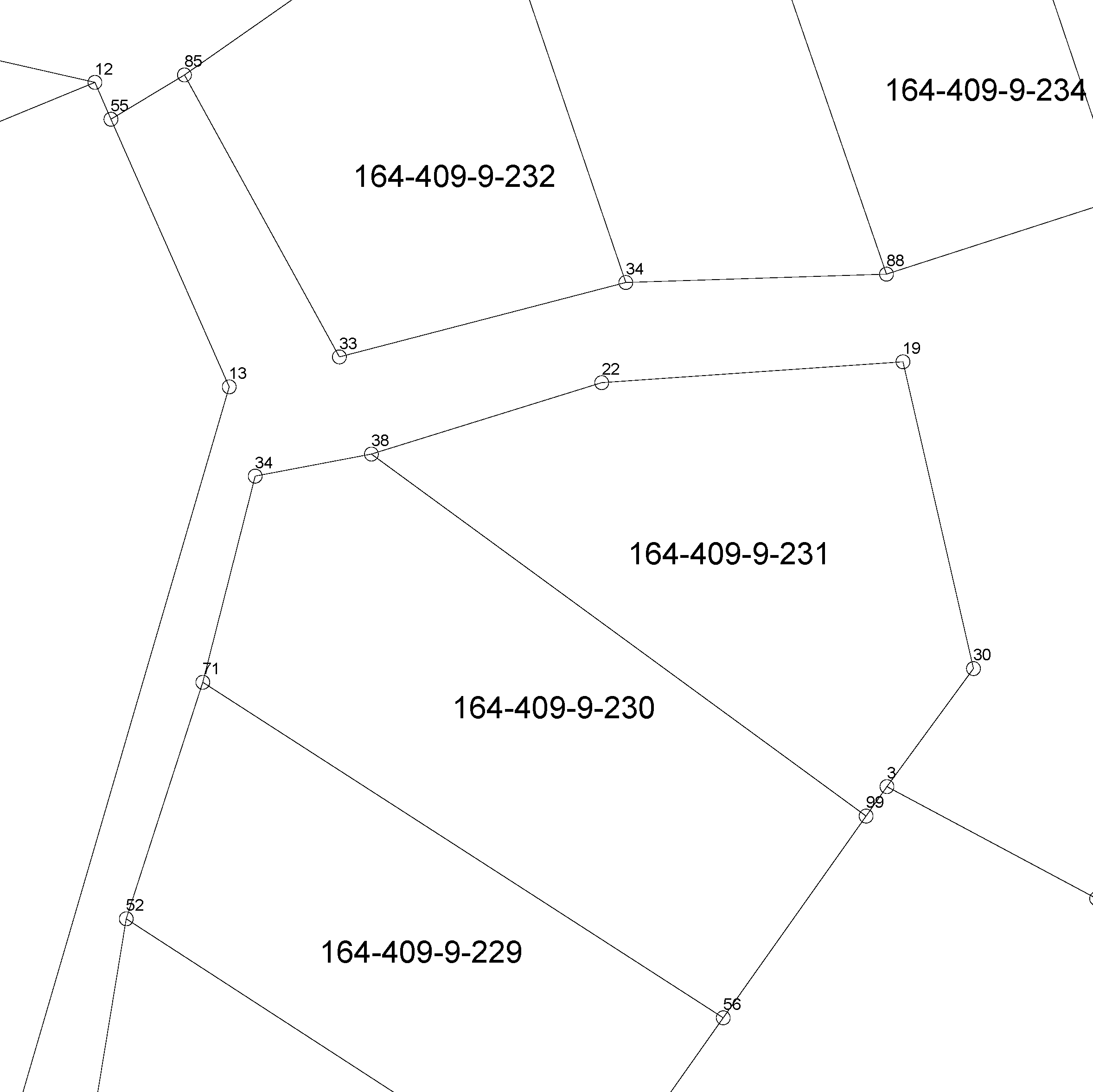
The location of the real property unit is shown on the cadastral index map. On the map, there are property and other register unit boundaries and property identifiers. The product is a part of the open data of the National Land Survey. Further information (in Finnish): http://www.maanmittauslaitos.fi/kiinteistot/asiantuntevalle-kayttajalle/kiinteistotiedot-ja-niiden-hankinta