 Paikkatietohakemisto
Maanmittauslaitos
Type of resources
Available actions
Topics
Keywords
Contact for the resource
Provided by
Years
Formats
Representation types
Update frequencies
Service types
Scale
Resolution
-
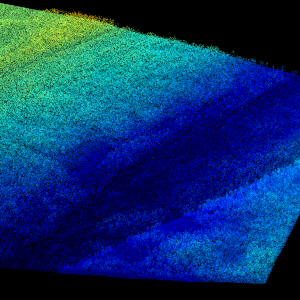
Laser scanning data refers to three-dimensional point-like data depicting the ground and objects on the ground. Each point is provided with x, y and z coordinate information. Laser scanning data 0.5 p has been spaced out from Laser scanning data 5 p's density of 5 p/m² to a density of 0.5 p/m². Laser scanning data 0.5 p is open data, and from 2020 onwards, it will be collected according to the national laser scanning programme (in Finnish): https://www.maanmittauslaitos.fi/laserkeilaus-ja-ilmakuvaus. For the time being, it is available only from certain parts of Finland. The product belongs to the open data of the National Land Survey of Finland. More information (in Finnish): https://www.maanmittauslaitos.fi/laserkeilausaineistot.
-
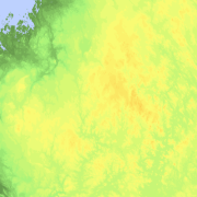
Elevation zones is a raster dataset that visualises elevation of the terrain. The product covers the whole of Finland. There are four product versions available in which the pixel sizes are 32, 64, 128 and 512 metres. The dataset does not contain elevation values; it is a colour image that visualises the height of the terrain above sea level as zones. The sea is shown in light blue in the elevation zone. The product Elevation zones is available as a version that covers the whole country and as versions that cover a certain area. The product belongs to the open data of the National Land Survey of Finland.
-
Laser scanning data refers to three-dimensional point-like data depicting the ground and objects on the ground. Each point is provided with x, y and z coordinate information. Laser scanning data is available from all of Finland. The product belongs to the open data of the National Land Survey of Finland. From 2020 onwards, laser scanning data according to the laser scanning programme will be produced. The product description of the 'Laser scanning data 5 p' according to the scanning programme is available: https://www.maanmittauslaitos.fi/en/maps-and-spatial-data/expert-users/product-descriptions/laser-scanning-data-5-p. A spaced-out open dataset will be created from the new Laser scanning data 5 p: https://www.maanmittauslaitos.fi/en/maps-and-spatial-data/expert-users/product-descriptions/laser-scanning-data-05-p. The characteristics of this dataset correspond to the Laser scanning data 2008–2019 dataset.
-

The map sheet division is a system created for printing maps, which covers map sheet codes, map scales and map sheet sizes. The map sheet division is a system created for printing maps, which covers map sheet codes, map scales and map sheet sizes. Today, map sheet division is also used for other purposes. It is also possible to download other NLS datasets in addition to maps in accordance with map sheet division. The map sheet division TM35, which is based on the projected coordinate reference system ETRS-TM35FIN is in use today. Before 2007, a map sheet division that was based on the KKS coordinate reference system was used. The TM35 map sheet division consists of 7 different grid sizes, the smallest scale is 1:200,000 and the largest is 1:5000. An explanation of how the grids are further split into more detailed grids and the principles of map sheet numbering is on the National Land Survey website (in Finnish) https://www.maanmittauslaitos.fi/kartat-ja-paikkatieto/kartat/osta-kartta/nain-loydat-oikean-karttalehden. The attribute data of the grids include map sheet number, the area of a square on the grid, perimeter and the coordinates of the centre of the square. The map sheet division is available as a file in vector format and through our contract-based WMTS service in raster format. In addition, you can view it in the geoportal Paikkatietoikkuna. The product is a part of the open data of the National Land Survey.
-
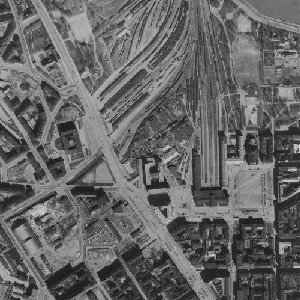
An aerial photograph is a photograph of the terrain taken from an aeroplane. The images are vertical photographs applicable to be used in mapping. The aerial photographs are reprocessed into dimensionally accurate images called orthophotos. Aerial photographs are available since the 1930s, depending on the area. Aerial photographs are available in black and white, colour and false colour. The size and accuracy of aerial photos depend on the camera, photography scale and altitude or ground sample distance (GSD). The product belongs to the open data of the National Land Survey of Finland. Aerial photographs can be ordered by pieces that cover a certain area. The latest orthophotos based on the aerial photographs can be downloaded free of charge from the File service of open data.
-

Paikkatietohakemisto is a national metadata discovery service.
-
Paikkatiedon tiedostopalvelu (OGC API Processes) tarjoaa kyselyrajapinnan, jonka kautta voi hakea Maanmittauslaitoksen avoimia paikkatietoaineistoja tiedostopaketteina. Aineistot ovat samat, joita voi hakea käyttöliittymän kautta Karttapaikka-palvelun Lataa paikkatietoaineistoja -osiosta. Aineistojen tarkemmat tiedot ovat luettavissa tuotekuvauksista https://www.maanmittauslaitos.fi/kartat-ja-paikkatieto/aineistot-ja-rajapinnat/tuotekuvaukset Palvelu sopii esimerkiksi käyttöön, jossa on tarvetta hakea paikkatietoaineistoja koordinaateilla eli suorakaiteella (Bounding Box) tai polygonirajauksella. Karttapaikan Lataa paikkatietoaineistoja-osiossa nämä valinnat piirretään kartalla, mutta OGC API Processes -palvelussa koordinaatit voi syöttää kyselyparametreina. Hakuparametrit vaihtelevat aineistosta riippuen. Osaa aineistoista voi hakea myös karttalehden, kunnan tai teeman perusteella, tai koko Suomen alueelta. Palvelusta saatavat aineistot ovat Maanmittauslaitoksen avoimen tietoaineiston Nimeä CC 4.0 -lisenssin alaisia. Palvelu tarjotaan avoimena rajapintana, jonka käyttö on maksutonta. Käyttäjä tunnistetaan API-avaimella. https://www.maanmittauslaitos.fi/rajapinnat/api-avaimen-ohje https://www.maanmittauslaitos.fi/paikkatiedon-tiedostopalvelu
-
Ortokuvien ja korkeusmallien kyselypalvelun (WCS) kautta voit hakea rasterimuotoisia ortokuvia ja korkeusmalleja. Palvelussa voit poimia haluttuja paloja aineistoista omalla aluerajauksellasi. Ortokuvien osalta palvelu sisältää Maanmittauslaitoksen väri-, vääräväri- ja mustavalkoisia ortokuvia eri vuosilta. Korkeusmalli on 2 m korkeusmallia, joka on tuotettu laserkeilausaineiston pohjalta. Korkeusmallia pystyy hakemaan palvelusta myös karkeammilla kuin 2m resoluutioilla. Tarjolla ovat seuraavat resoluutiot: 2 m, 4 m, 8 m, 16 m, 32 m, 64 m, 128 m, 256 m ja 512 m. Ortokuvat ovat saatavilla palvelusta GeoTIFF-formaatissa ja korkeusmalli GeoTIFF- tai ASCII Grid -formaatissa. Palvelun käyttäminen edellyttää perehtyneisyyttä paikkatietorajapintojen ohjelmalliseen hyödyntämiseen. Yksittäisten latausten tekeminen onnistuu myös selaimella. Ladatut tiedostot saat auki ja voit jatkokäsitellä paikkatieto-ohjelmalla. Toistaiseksi palvelua ei pysty käyttämään esimerkiksi QGIS -ohjelmalla. Aineistot ovat Maanmittauslaitoksen avoimen tietoaineiston Nimeä CC 4.0 -lisenssin alaisia. Palvelu tarjotaan avoimena rajapintana, jonka käyttö on maksutonta. Käyttäjä tunnistetaan API-avaimella. Lue lisää Maanmittauslaitoksen avoimen rajapinnan käyttöehdoista ja API-avaimen luomisesta ja käyttämisestä. https://www.maanmittauslaitos.fi/rajapinnat/api-avaimen-ohje https://www.maanmittauslaitos.fi/ortokuvien-ja-korkeusmallien-kyselypalvelu
-
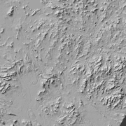
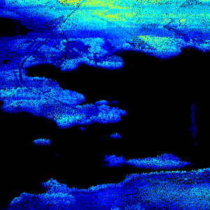
Hillshade (elevation model) is a raster dataset visualising the elevation of the terrain. There are five product versions available in which the pixel sizes are 2, 8, 32, 64, 128 and 512 metres. Pixel size 2 m has been produced of the dataset Elevation model 2 m. The other sizes have been produced of the dataset Elevation model 10 m. The material does not contain elevation values; it is a greyscale image that visualises the direction and steepness of hills. The product belongs to the open data of the National Land Survey of Finland.
-
National Land Survey's geographic names are available as interfaces and files. Interfaces and file products comprise of place name products and map name products. The place name products include data about approximately 800,000 named places and their names in different languages. Data about place are among others place type, plane location and height above sea level, and data about names are among others the spelling that has been checked by the Institute for the Languages of Finland and language (Finnish, Swedish, Northern Sami, Inari Sami or Skolt Sami. In the place name products, every place and its name or names appear only once. The map name products contain the place names that have been selected for the National Land Survey's nine standard map products and information about the cartographical presentation of them. The information includes the location of the name on the map, for instance the coordinates of the left lower corner of the map text, the direction and bending of the text as well as typographical information, such as font type, size and colour. The name of a particular place, such as a river, can appear several times in the same map product. The product is a part of the open data of the National Land Survey.