2015
Type of resources
Available actions
Topics
Provided by
Years
Formats
Representation types
Scale
-

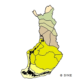
Suokasvillisuuden aluejako perustuu suoyhdistymätyyppeihin. Jako on digitoitu teoksesta Suomen kartasto, vihko 141-143, Ruuhijärvi, R.1988: Suokasvillisuus. Merialueen vyöhykerajat on digitoitu R. Ruuhijärven erikseen määritteleminä v.2002. Aineisto kuuluu SYKEn avoimiin aineistoihin (CC BY 4.0). Aineistosta on julkaistu INSPIRE-tietotuote. Käyttötarkoitus: Aineistoa käytetään taustakarttojen tuottamiseen ja karkeisiin analyyseihin. The mire vegetation zones dataset includes information on vegetation zones based on combinations of different mire types. The distribution of zones has been digitized from the mire vegetation maps of the Finnish map book (Suomen kartasto, book 141-143, Ruuhijärvi, R 1998: Suokasvillisuus). The mire zones are extended to outer sea areas based on the identification made by R. Ruuhijärvi on 2002. The Finnish national borders are based on the Digital Chart of the World (DCW) dataset with coastline corrections done by Syke. The dataset has been fitted to match the outer borders of the national waters (digitized in Syke). This Syke’s dataset can be used according to open data license (CC BY 4.0). INSPIRE compatible dataset has been published.
 Paikkatietohakemisto