 Paikkatietohakemisto
Land cover
Type of resources
Available actions
Topics
Keywords
Contact for the resource
Provided by
Formats
Representation types
Update frequencies
Service types
Scale
-
Conditionality refers to the basic requirements that farmers' payments are conditional upon. Conditionality requirements are the baseline level for which you do not receive a separate payment. Aid is only granted for activities that go beyond the conditionality requirements. Conditionality consists of GAEC, statutory management requirements and social conditionality. Statutory management requirements relate to environmental issues, public health, i.e. food and feed safety, plant health and animal health and welfare. All conditionality requirements are described in this guide. When you apply for farmer payments, you agree to comply with the conditionality requirements. A landscape feature can be a tree, group of trees, transplanted block or other similar natural feature that is protected for its beauty, rarity, landscape significance, scientific value or other similar reason. Qualifying landscape features are sites protected under Article 95 of the Nature Conservation Act (9/2023) and located within a base parcel, on the periphery of a base parcel or in the area between adjacent base parcels. Protected sites must always be preserved and must not be damaged or removed. If a protected landscape feature is located on an area of 0,2 ha or less, it may be included in the area of the base parcel. If you wish to include a protected site in the eligible area, please declare the sites on the Food Agency's form 442 when applying for arable aid. The area of a landscape feature will only become part of the eligible area of the base parcel in the year following the submission of the declaration. Who makes conservation decisions on sites? If the site to be protected is located on private land, the decision to protect the site is taken by the municipality's environmental protection authority. The municipality is also responsible for marking the site on the land. On private land, protection is only granted on application or with the consent of the landowner. On application by the owner or on a proposal from the ELY Centre, the municipality may terminate the protection of a landscape feature if there are no longer grounds for protecting it or if the protection prevents the implementation of a project or plan of public interest. The application must be accompanied by the opinion of the ELY Centre. If the matter has been initiated on the basis of a proposal from the ELY Centre, the owner of the site must be given the opportunity to be heard. For more information: https://www.ruokavirasto.fi/tuet/maatalous/perusehdot/ehdollisuus/ehdollisuuden-opas/ehdollisuuden-opas-2025/
-
-
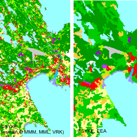
CORINE Land Cover 2000 kuvaa koko Suomen maankäyttöä ja maanpeitettä vuonna 2000. Aineisto koostuu rasterimuotoisesta paikkatietokannasta (erotuskyky 25 * 25 m) ja vektorimuotoisesta paikkatietokannasta, jossa pienin maastossa erottuva alue on vähintään 25 ha ja kapeimmillaan 100 metriä. Aineisto on tuotettu Sykessä olemassa oleviin paikkatietoaineistoihin sekä satelliittikuvatulkintaan perustuen. Vektoriaineisto tuotettiin yleistämällä rasteriaineistoa eurooppalaisen CLC2000 -hankkeen sääntöjen mukaan. Vektoriaineistoissa maankäyttöä/maanpeitettä kuvataan kolmitasoisella hierarkisella luokittelulla. Viisi pääluokkaa ( rakennetut alueet; maatalousalueet; metsät sekä avoimet kankaat ja kalliomaat; kosteikot ja avoimet suot sekä vesialueet) jaetaan toisella tasolla yhteensä 15 alaluokkaan. Kolmannella luokittelutasolla pääluokat jaetaan yhteensä 44 alaluokkaan. Rasteriaineistossa on joidenkin luokkien kohdalla vielä neljännen tason kansallisia luokkia. Aineisto kuuluu SYKEn avoimiin aineistoihin (CC BY 4.0). Aineistosta on julkaistu INSPIRE-tietotuote. Käyttötarkoitus: Vektoriaineisto, jossa minimikuviokoko on 25 ha, on tuotettu Euroopan ympäristövirastolle osana Euroopan laajuista CORINE-hanketta. Tarkempi 25 m resoluutiolla oleva rasteriaineisto on tarkoitettu kansalliseen käyttöön kuvaamaan maanpeitettä/maankäyttöä. Aineistoja voidaan käyttää paikkatietoanalyysien lisäksi myös taustakarttoina. Lisätietoja: https://geoportal.ymparisto.fi/meta/julkinen/dokumentit/CorineLandCover2000.pdf https://geoportal.ymparisto.fi/meta/julkinen/dokumentit/clc2000_luokat.xls http://www.syke.fi/fi-FI/Tutkimus__kehittaminen/Tutkimus_ja_kehittamishankkeet/Hankkeet/Maankaytto_ja_maanpeiteaineistojen_tuottaminen_CORINE_Land_Cover_2000_hankkeessa/Maankaytto_ja_maanpeiteaineistojen_tuott%289788%29 https://geoportal.ymparisto.fi/meta/julkinen/dokumentit/clc2000_luokat.pdf CORINE Land Cover 2000 dataset provides information on Finnish land cover and land use on 2000. The data was produced as a part of the European CLC 2000 project. Dataset includes several spatial layers: • CLC raster (resolution of 25x25 m) • CLC vector (minimum mapping unit 25 hectares and minimum width 100 m) • Source raster (resolution of 25x25 m) on the source data used in the interpretation • Age raster (resolution of 25x25 m) on the year of the soure information The dataset has been produced in the Finnish Environment Institute (Syke), based on automated interpretation of satellite images and data integration with existing digital map data. The vector dataset was produced from raster data by generalization according to the CORINE 2000 project class definitions. The nomenclature of the vector data has 3 hierarchy levels. The first level classes are: artificial surfaces, agricultural areas, forests and seminatural areas, wetlands and open bogs, water and marshes. Second level has 15 classes and third level 44 sub-classes. The raster dataset has an additional fourth, national class in some of the sub-classes. The vector land cover dataset (25 ha) was produced for the European Environment Agency as a part of the European CORINE-project for harmonized land cover map and statistics in Europe. The more specific raster dataset (25 m x 25 m) was produced for national use to provide information on Finnish land cover and land use. The datasets are can be used in analyses and as background maps. Information on the source material and age of the source element can be used to validate the results of analyses. The source material is generally from year 2000 (+/- 1 year).
-
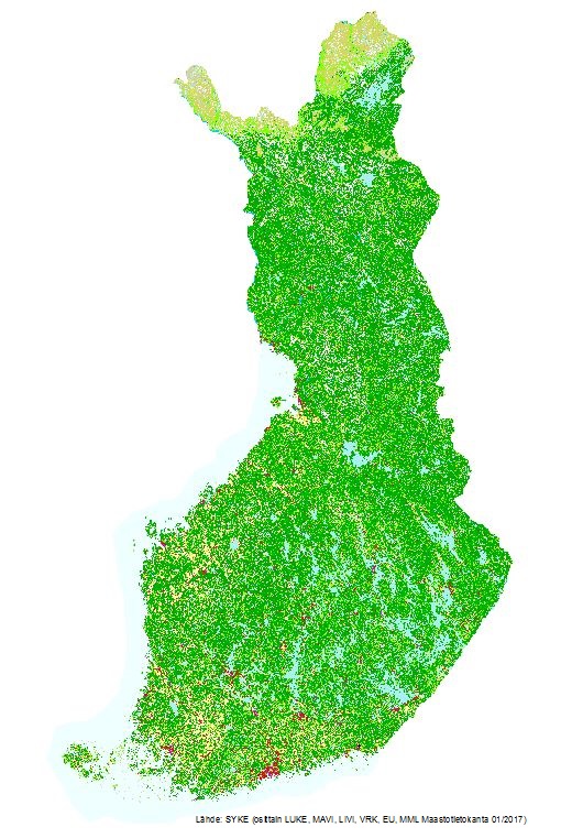
CORINE Land Cover 2018 kuvaa koko Suomen maankäyttöä ja maanpeitettä vuonna 2018. Sykessä EU:n Copernicus Land -hankkeessa tuotettiin Suomen alueelta maanpeiteaineistot sekä laadittiin maanpeitteen muutoksia välillä 2012-2018 kuvaavat aineistot. Aineistot luotiin kahdella tarkkuustasolla: toinen EU-vaatimusten mukaisesti ja toinen kansalliseen käyttöön. Aineisto koostuu rasterimuotoisesta paikkatietokannasta (erotuskyky 20 * 20 m) ja vektorimuotoisesta paikkatietokannasta, jossa pienin maastossa erottuva alue on vähintään 25 ha ja kapeimmillaan 100 metriä. Kansallisen muutosaineiston 2012-2018 pienin kuvio on 0,5 ha ja eurooppalaisen 5 ha. Aineisto on tuotettu Sykessä olemassa oleviin paikkatietoaineistoihin sekä satelliittikuvatulkintaan perustuen. Vektoriaineisto tuotettiin yleistämällä rasteriaineistoa EEA:n CORINE-sääntöjen mukiseksi. Vektoriaineistoissa maankäyttöä/maanpeitettä kuvataan kolmitasoisella hierarkisella luokittelulla. Viisi pääluokkaa (rakennetut alueet; maatalousalueet; metsät sekä avoimet kankaat ja kalliomaat; kosteikot ja avoimet suot sekä vesialueet) jaetaan toisella tasolla yhteensä 15 alaluokkaan.. Kolmannella luokittelutasolla luokat jaetaan edelleen yhteensä 44 alaluokkaan. Rasteriaineistossa on joidenkin luokkien kohdalla vielä neljännen tason kansallisia luokkia. Aineisto kuuluu SYKEn avoimiin aineistoihin (CC BY 4.0). Aineistosta on julkaistu INSPIRE-tietotuote. Käyttötarkoitus: Vektoriaineisto, jossa minimikuviokoko on 25 ha/muutos 5 ha, on tuotettu Euroopan ympäristövirastolle. Tarkempi 20 m resoluutiolla oleva rasteriaineisto ja 1 ha muutosaineisto on tarkoitettu kansalliseen käyttöön kuvaamaan maanpeitettä/maankäyttöä. Aineistoja voidaan käyttää paikkatietoanalyysien lisäksi myös taustakarttoina. Lisätietoja: https://www.syke.fi/fi-FI/Tutkimus__kehittaminen/Tutkimus_ja_kehittamishankkeet/Hankkeet/Maankaytto_ja_maanpeiteaineistojen_tuottaminen_CORINE_Land_Cover_2018_hankkeessa_ja_Copernicus_Land__aineistojen_validointi_Suomessa https://geoportal.ymparisto.fi/meta/julkinen/dokumentit/CorineMaanpeite2018.pdf https://geoportal.ymparisto.fi/meta/julkinen/dokumentit/CorineMaanpeite2018Luokat.xls https://geoportal.ymparisto.fi/meta/julkinen/dokumentit/CorineMaanpeite2018Luokkakuvaus.pdf CORINE Land Cover 2018 dataset provides information on Finnish land cover and land use on 2018, and its changes from 2012 to 2018. The data was produced as a part of EU Copernicus Land project. The dataset includes several spatial layers: • CLC raster (resolution of 20x20 m) • CLC vector (minimum mapping unit 25 hectares and minimum width 100 m). • Change vector (minimum mapping unit 5 hectares) • Change raster (minimum mapping unit 0,5 hectares) The dataset has been produced in Finnish Environment Institute (Syke), based on automated interpretation of satellite images and data integration with existing digital map data. The vector dataset was produced from raster data by generalization according to the CORINE 2018 project class definitions. The nomenclature of the vector data has 3 hierarchy levels. The first level classes are: artificial surfaces, agricultural areas, forests and seminatural areas, wetlands and water. The second level has 15 classes and the third level 44 sub-classes. The raster dataset has an additional fourth, national class in some of the sub-classes. Syke applies Creative Commons By 4.0 International license for open datasets. Data was produced with funding by the European Union. Copyright Copernicus Programme. Syke has undertaken to distribute the data on behalf of EEA under Specific Contract No 3436/R0-Copernicus/EEA.56936 implementing Framework service contract No EEA/IDM/R0/16/009/Finland. Syke accepts no responsibility or liability whatsoever with regard to the content and use of these data. The vector land cover dataset (25 ha) and the change dataset (5 ha) were produced for the European Environment Agency as a part of EU Copernicus Land project for harmonized land cover maps and statistics in Europe. The more specific raster dataset (20 m x 20 m) and the change (0,5 ha) were produced for national use to provide information on Finnish land cover and land use. The datasets can be used in analyses and as background maps. The source material is generally from years 2016-2017.
-
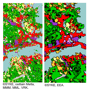
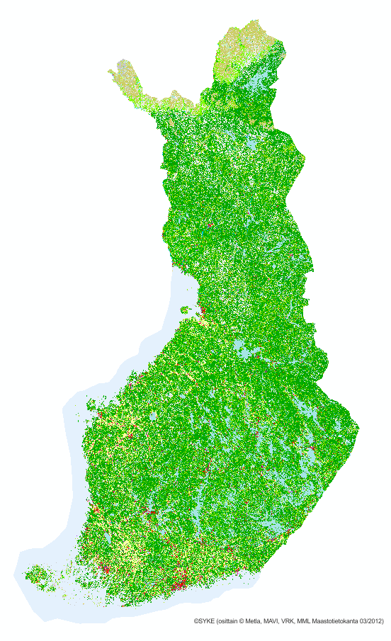
CORINE Land Cover 2006 kuvaa koko Suomen maankäyttöä ja maanpeitettä vuonna 2006. Eurooppalaisessa CLC2006 -projektissa tuotettiin Suomen alueelta vuoden 2006 maanpeiteaineistot sekä laadittiin maanpeitteen muutoksia välillä 2000-2006 kuvaavat aineistot. Aineistot luotiin kahdella tarkkuustasolla: EU vaatimusten mukaisesti ja kansalliseen käyttöön. Aineisto koostuu rasterimuotoisesta paikkatietokannasta (erotuskyky 25 * 25 m) ja vektorimuotoisesta paikkatietokannasta, jossa pienin maastossa erottuva alue on vähintään 25 ha ja kapeimmillaan 100 metriä. Kansallisen muutosaineiston pienin kuvio on 1 ha ja eurooppalaisen 5 ha. Aineisto on tuotettu Sykessä olemassa oleviin paikkatietoaineistoihin sekä satelliittikuvatulkintaan perustuen. Vektoriaineisto tuotettiin yleistämällä rasteriaineistoa eurooppalaisen CORINE2006-hankkeen sääntöjen mukaan. Vektoriaineistoissa maankäyttöä/maanpeitettä kuvataan kolmitasoisella hierarkisella luokittelulla. Viisi pääluokkaa ( rakennetut alueet; maatalousalueet; metsät sekä avoimet kankaat ja kalliomaat; kosteikot ja avoimet suot sekä vesialueet) jaetaan toisella tasolla yhteensä 15 alaluokkaan.. Kolmannella luokittelutasolla pääluokat jaetaan yhteensä 44 alaluokkaan. Rasteriaineistossa on joidenkin luokkien kohdalla vielä neljännen tason kansallisia luokkia. Aineisto kuuluu SYKEn avoimiin aineistoihin (CC BY 4.0). Aineistosta on julkaistu INSPIRE-tietotuote. Käyttötarkoitus: Vektoriaineisto, jossa minimikuviokoko on 25 ha/muutos 5 ha, on tuotettu Euroopan ympäristövirastolle osana Euroopan laajuista CORINE-hanketta. Tarkempi 25 m resoluutiolla oleva rasteriaineisto ja 1 ha muutosaineisto on tarkoitettu kansalliseen käyttöön kuvaamaan maanpeitettä/maankäyttöä. Aineistoja voidaan käyttää paikkatietoanalyysien lisäksi myös taustakarttoina. Lisätietoja: https://geoportal.ymparisto.fi/meta/julkinen/dokumentit/CorineLandCover2006.pdf https://geoportal.ymparisto.fi/meta/julkinen/dokumentit/clc2006_luokat.xls http://www.syke.fi/fi-FI/Tutkimus__kehittaminen/Tutkimus_ja_kehittamishankkeet/Hankkeet/Maankaytto_ja_maanpeiteaineistojen_tuottaminen_CORINE_Land_Cover_2006_hankkeessa/Maankaytto_ja_maanpeiteaineistojen_tuott%289088%29 https://geoportal.ymparisto.fi/meta/julkinen/dokumentit/clc2006_luokat.pdf CORINE Land Cover 2006 dataset provides information on Finnish land cover and land use on 2006, and it's changes from 2000 to 2006. The data was produced as a part of the European CLC 2006 project. Dataset includes several spatial layers: • CLC raster (resolution of 25x25 m) and one in • CLC vector (minimum mapping unit 25 hectares and minimum width 100 m). • Source raster (resolution of 25x25 m) on the source data used in the interpretation • Age raster (resolution of 25x25 m) on the year of the soure information • Change vector (minimum mapping 5 hectares) • Change raster (minimum mapping unit 1 hectares) The dataset has been produced in the Finnish Environment Institute (Syke), based on automated interpretation of satellite images and data integration with existing digital map data. The vector dataset was produced from raster data by generalization according to the CORINE 2006 project class definitions. The nomenclature of the vector data has 3 hierarchy levels. The first level classes are: artificial surfaces, agricultural areas, forests and seminatural areas, wetlands and open bogs, water and marshes. Second level has 15 classes and third level 44 sub-classes. The raster dataset has an additional fourth, national class in some of the sub-classes. The vector land cover dataset (25 ha) and the change dataset (5 ha) were produced for the European Environment Agency as a part of the European CORINE-project for harmonized land cover maps and statistics in Europe. The more specific raster dataset (25 m x 25 m) and the change (1 ha) was produced for national use to provide information on Finnish land cover and land use. The datasets are can be used in analyses and as background maps. Information on the source material and age of the source element can be used to validate the results of analyses. The source material is generally from year 2006 (+/- 1 year).
-
CORINE Land Cover 2012 kuvaa koko Suomen maankäyttöä ja maanpeitettä vuonna 2012. Sykessä EU:n Copernicus Gioland-hankkeessa tuotettiin Suomen alueelta maanpeiteaineistot sekä laadittiin maanpeitteen muutoksia välillä 2006-2012 kuvaavat aineistot. Aineistot luotiin kahdella tarkkuustasolla: EU-vaatimusten mukaisesti ja kansalliseen käyttöön. Aineisto koostuu rasterimuotoisesta paikkatietokannasta (erotuskyky 20 * 20 m) ja vektorimuotoisesta paikkatietokannasta, jossa pienin maastossa erottuva alue on vähintään 25 ha ja kapeimmillaan 100 metriä. Kansallisen muutosaineiston 2006-2012 pienin kuvio on 0,5 ha ja eurooppalaisen 5 ha. Suoria pikselien vertailuja vuoteen 2006 ei suositella tekemään vaan muutokset kannattaa hakea muutosaineistosta. Aineisto on tuotettu Sykessä olemassa oleviin paikkatietoaineistoihin sekä satelliittikuvatulkintaan perustuen. Vektoriaineisto tuotettiin yleistämällä rasteriaineistoa EEA:n CORINE-sääntöjen mukaan. Vektoriaineistoissa maankäyttöä/maanpeitettä kuvataan kolmitasoisella hierarkisella luokittelulla. Viisi pääluokkaa (rakennetut alueet; maatalousalueet; metsät sekä avoimet kankaat ja kalliomaat; kosteikot ja avoimet suot sekä vesialueet) jaetaan toisella tasolla yhteensä 15 alaluokkaan. Kolmannella luokittelutasolla pääluokat jaetaan yhteensä 44 alaluokkaan. Rasteriaineistossa on joidenkin luokkien kohdalla vielä neljännen tason kansallisia luokkia. Aineisto kuuluu SYKEn avoimiin aineistoihin (CC BY 4.0). Aineistosta on julkaistu INSPIRE-tietotuote. Käyttötarkoitus: Vektoriaineisto, jossa minimikuviokoko on 25 ha/muutos 5 ha, on tuotettu Euroopan ympäristövirastolle. Tarkempi 20 m resoluutiolla oleva rasteriaineisto ja 1 ha muutosaineisto on tarkoitettu kansalliseen käyttöön kuvaamaan maanpeitettä/maankäyttöä. Aineistoja voidaan käyttää paikkatietoanalyysien lisäksi myös taustakarttoina. Lähtöaineistojen tarkkuus ja tuotantomenetelmät saattavat vaihdella vuodesta toiseen ja myös pikselikoko eroaa, joten suora muutosvertailu vuoden 2006 aineistoon ei toimi, vaan on käytettävä erillistä muutostulkintaa. Lisätietoja: http://www.syke.fi/fi-FI/Tutkimus__kehittaminen/Tutkimus_ja_kehittamishankkeet/Hankkeet/Maankaytto_ja_maanpeiteaineistojen_tuottaminen_CORINE_Land_Cover_2012_hankkeessa/Maankaytto_ja_maanpeiteaineistojen_tuott%289085%29 https://geoportal.ymparisto.fi/meta/julkinen/dokumentit/CorineMaanpeite2012.pdf https://geoportal.ymparisto.fi/meta/julkinen/dokumentit/CorineMaanpeite2012Luokat.xls https://geoportal.ymparisto.fi/meta/julkinen/dokumentit/CorineMaanpeite2012Luokkakuvaus.pdf CORINE Land Cover 2012 dataset provides information on Finnish land cover and land use on 2012, and its changes from 2006 to 2012. The data was produced as a part of the European Gioland 2012 project. Dataset includes several spatial layers: • CLC raster (resolution of 20x20 m) • CLC vector (minimum mapping unit 25 hectares and minimum width 100 m) • Source raster (resolution of 20x20 m) on the source data used in the interpretation • Age raster (resolution of 20x20 m) on the year of the source information • Change vector (minimum mapping unit 5 hectares) • Change raster (minimum mapping unit 0,5 hectares) The dataset has been produced in Finnish Environment Institute (Syke), based on automated interpretation of satellite images and data integration with existing digital map data. The vector dataset was produced from raster data by generalization according to the CORINE 2012 project class definitions. The nomenclature of the vector data has 3 hierarchy levels. The first level classes are: artificial surfaces, agricultural areas, forests and seminatural areas, wetlands and water. The second level has 15 classes and the third level 44 sub-classes. The raster dataset has an additional fourth, national class in some of the sub-classes. The vector land cover dataset (25 ha) and the change dataset (5 ha) were produced for the European Environment Agency as a part of the European Gioland project for harmonized land cover maps and statistics in Europe. The more specific raster dataset (20 m x 20 m) and the change (0,5 ha) were produced for national use to provide information on Finnish land cover and land use. The datasets can be used in analyses and as background maps. Information on the source material and age of the source element can be used to validate the results of analyses. The source material is generally from year 2012 (+/- 1 year). https://geoportal.ymparisto.fi/meta/julkinen/dokumentit/CorineLandCover2012_en.pdf https://geoportal.ymparisto.fi/meta/julkinen/dokumentit/Corinemaanpeite2012luokat.xls https://geoportal.ymparisto.fi/meta/julkinen/dokumentit/Corinemaanpeite2012luokkakuvaus.pdf
-
Field parcel register The field parcel register is an annual file containing the reference parcels covered by the annual aid application. A reference parcel is a geographically homogeneous area of land cultivated and owned or managed by an individual applicant (excluding commonly used land) and bounded by a municipal boundary, a property boundary, a subsidy or contract area boundary, a watercourse, a district or river, a road, a forest or other similar boundary. A homogeneous area in terms of geography, eligibility and type of land use owned by an aid applicant is a single reference parcel, even if it is made up of several separate registered parcels owned by the applicant. The aim of the definition of valuable data (EU) 2023/138 has been to ensure that the most socially potential public data are re-available. The Food Authority is concerned with the theme of spatial data: reference parcels and agricultural parcels From 2023 onwards, the Food Authority will add attributes to the published data as follows: Field parcel register - Organic production - Slope, ha (Sloping areas in base parcels with a slope of more than 15% in mainland Finland and more than 10% in Åland). - Groundwater area, ha - Natura area, ha - Buffer stripping requirement (metres), m The following new fields are included in the data: LUOMUVILJELY = Organic production: 1=absent or 0=no KALTEVA_ALA = SLOPE_AREA: Sloping areas in the base parcel. Slope in mainland Finland over 15 % and in Åland over 10 %, ha POHJAVESI_ALA = SHOREWATER_AREA: ha NATURA_ALA = NATURA_AREA: ha SUOJAKAISTA_M: Bufferstrip requirement (on parcel) , m. More information at: https://www.ruokavirasto.fi/globalassets/tuet/maatalous/oppaat/hakuoppaat/peltotukiopas/peltotukien-hakuopas-2024.pdf
-
-
-
Palvelu tarjoaa tietoja muun muassa liikenneverkoista, rakennuksista ja rakenteista, hallintorajoista, nimistöstä, maankäytöstä, vesistöistä ja korkeussuhteista. Aineistolähteenä on Maanmittauslaitoksen Maastotietokanta, jonka kohteita pidetään jatkuvasti ajan tasalla. Aineistot ovat Maanmittauslaitoksen avoimen tietoaineiston Nimeä CC 4.0 -lisenssin alaisia. Palvelu tarjotaan avoimena rajapintana, jonka käyttö on maksutonta. Käyttäjä tunnistetaan API-avaimella. Lue lisää Maanmittauslaitoksen avoimen rajapinnan käyttöehdoista ja API-avaimen luomisesta ja käyttämisestä. https://www.maanmittauslaitos.fi/rajapinnat/api-avaimen-ohje
-

The Topographic database is a dataset depicting the terrain of all of Finland. The key objects in the Topographic database are the road network, buildings and constructions, administrative borders, geographic names, land use, waterways and elevation. Aerial photographs, scanning data and data provided by other data providers are utilised in updating the Topographic database. The updating is done in close cooperation with the municipalities. Field checks in the terrain are also needed to some extent, mostly as regards the classification of features. The topographic database is used in the production of other map products and in various optimisation tasks. The product belongs to the open data of the National Land Survey of Finland.