 Paikkatietohakemisto
National
Type of resources
Available actions
Topics
Keywords
Contact for the resource
Provided by
Years
Formats
Representation types
Update frequencies
Scale
-
NLS-FI INSPIRE Cadastral Parcels Theme Dataset is a dataset depicting the Cadastral Parcels and Basic Property Units covering the whole of Finland. It contains the following INSPIRE feature types: BasicPropertyUnit, CadastralParcel, CadastralBoundary. The elements are updated weekly. The dataset is based on the NLS Cadastral Index Map database. The dataset is available via the NLS-FI INSPIRE Download Service (WFS) for Cadastral Parcels Theme and it can be viewed via the NLS-FI INSPIRE View Service (WMS) for Cadastral Parcels.
-
NLS-FI INSPIRE Administrative Units Theme Dataset is a dataset depicting Administrative Units covering the land area and Maritime Units covering the sea area of Finland. Administrative Units contain the following INSPIRE feature types: AdministrativeUnit, AdministrativeBoundary. Maritime Units contain the following INSPIRE feature types: Baseline, MaritimeZone, MaritimeBoundary. Administrative Units are updated once a year from the NLS Cadastral Index Map database. Maritime Units are quite stable and have no regular update cycle. The dataset is available via the NLS-FI INSPIRE Download Service (WFS) for Administrative Units Theme and it can be viewed via the NLS-FI INSPIRE View Service (WMS) for Administrative Units.
-
NLS-FI INSPIRE Buildings Theme Dataset is a dataset depicting the Buildings covering the whole of Finland. It contains the following INSPIRE feature types: Building The elements are updated weekly. The dataset is based on the NLS Topographic database: http://www.paikkatietohakemisto.fi/geonetwork/srv/en/main.home?uuid=cfe54093-aa87-46e2-bfa2-a20def7b036f. Id-attribute indicates the topographic database id for features (mtk-id). The dataset is available via the NLS-FI INSPIRE Download Service (WFS) for Buildings Theme and it can be viewed via the NLS-FI INSPIRE View Service (WMS) for Buildings.
-
NLS-FI INSPIRE Geographical Names Theme Dataset is a dataset depicting the Named Places and Geographical Names covering the whole of Finland. It contains the following INSPIRE feature types: NamedPlace The elements are updated weekly. The dataset is based on the Geographic Names Register of the National Land Survey of Finland: http://www.paikkatietohakemisto.fi/geonetwork/srv/fin/catalog.search#/metadata/eec8a276-a406-4b0a-8896-741cd716ade6 The dataset is available via the NLS-FI INSPIRE Download Service (WFS) for Geographical Names Theme and it can be viewed via the NLS-FI INSPIRE View Service (WMS) for Geographical Names.
-
Elevation model 2 m is a model depicting the elevation of the ground surface in relation to sea level. Its grid size is 2 m x 2 m. The dataset is based on laser scanning data, the point density of which is at least 0.5 points per square metre. The product's coverage is based on nationwide laser scanning. In some parts of the outer archipelago or the eastern border, the elevation model is not available. Elevation model 2 m is produced in two quality classes: the elevation accuracy in class I is on average 0.3 metres and the elevation accuracy in class II varies between 0.3 metres and one metre. The product belongs to the open data of the National Land Survey of Finland.
-
NLS-FI INSPIRE Hydrography Theme Dataset is a dataset depicting the Hydrography Physical Waters covering the whole of Finland. It contains the following INSPIRE feature types: Dam Or Weir, Land-water Boundary, Rapids, Shoreline Construction, Standing Water, Watercourse. The elements are updated approximately every 5–10 years. The dataset is based on the NLS Topographic database: https://www.paikkatietohakemisto.fi/geonetwork/srv/eng/catalog.search#/metadata/cfe54093-aa87-46e2-bfa2-a20def7b036f The dataset is available via the NLS-FI INSPIRE Download Service (WFS) for Hydrography Theme and it can be viewed via NLS-FI INSPIRE View Service (WMS) for Hydrography. http://paikkatiedot.fi/so/4dae5686-2a8c-40d8-837f-ce6f5547dba2
-
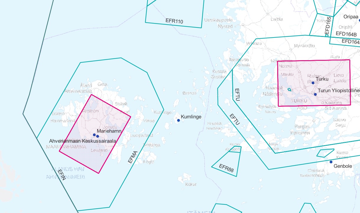
Air traffic network-product is a link-knot routing dataset compliant with INSPIRE requirements. It includes f.ex. flight routes and aerodromes. Data shall not be used for operational flight activities or flight planning. INSPIRE Air Traffic Network-product includes spatial information of air traffic network in accordance with the INSPIRE Directive. The data has been retrieved from the EAD database maintained by Eurocontrol. Information is updated regularly but is not constantly up to date. Data can be used for purposes that are in accordance with the INSPIRE Directive, but shall not be used for operational flight activities or flight planning. ANS Finland www.ais.fi –site provides information for operational flight activities or flight planning Available layers Aerodrome Node: Node located at the aerodrome reference point of an airport/heliport, which is used to represent it in a simplified way.DEFINITION Aerodrome Reference Point (ARP): The designated geographical location of an aerodrome, located near the initial or planned geometric centre of the aerodrome and normally remaining where originally established [AIXM3.3].DEFINITION Airport/heliport: A defined area on land or water (including any buildings, installations and equipment) intended to be used either wholly or in part for the arrival, departure and surface movement of aircraft/helicopters [AIXM5.0]. Air Route Link: A portion of a route to be flown usually without an intermediate stop, as defined by two consecutive significant points Air Space Area: A defined volume in the air, described as horizontal projection with vertical limits. Designated Point: A geographical location not marked by the site of a radio navigation aid, used in defining an ATS route, the flight path of an aircraft or for other navigation or ATS purposes. Instrument Approach Procedure: A series of predetermined manoeuvres by reference to flight instruments with specified protection from obstacles from the initial approach fix, or where applicable, from the beginning of a defined arrival route to a point from which a landing can be completed and thereafter, if a landing is not completed, to a position at which holding or en route obstacle clearance criteria apply. Navaid: One or more Navaid Equipments providing navigation services.DEFINITION Navaid equipment: A physical navaid equipment like VOR, DME, localizer, TACAN or etc. Procedure Link: A series of predetermined manoeuvres with specified protection from obstacles. Runway Area: A defined rectangular area on a land aerodrome/heliport prepared for the landing and take-off of aircraft. Runway Centerline Point: An operationally significant position on the center line of a runway direction. Standard Instrument Arrival: A designated instrument flight rule (IFR) arrival route linking a significant point, normally on an ATS route, with a point from which a published instrument approach procedure can be commenced. Standard Instrument Departure: A designated instrument flight rule (IFR) departure route linking the aerodrome or a specific runway of the aerodrome with a specified significant point, normally on a designated ATS route, at which the en-route phase of a flight commences. Surface Composition: Runway surface material CTR (Not INSPIRE): A control zone (CTR) is a block of Controlled Airspace extending from the surface of the earth to a specified upper limit.
-
RRakennetun ympäristön tietojärjestelmä, Ryhti, kokoaa yhteen rakentamisen ja alueidenkäytön tiedot valtakunnallisesti. Tiedot syntyvät kuntien ja maakuntien liittojen perustyössä, ja ne toimitetaan valtakunnalliseen tietojärjestelmään ensisijaisesti rajapinnan kautta. Järjestelmään toimitettavat rakentamisen tiedot ovat rakentamislupa, purkamislupa, maisematyölupa ja poikkeamispäätös. Tietojen mukana toimitetaan kohteiden osoitteet. Osoitteet syntyvät Ryhtiin rakenteisessa muodossa. Ensimmäisessä vaiheessa osoitteilla ei ole omia sijaintipisteitä vaan ne kohdistetaan rakennuskohteisiin. Rakentamisen tiedot ovat valtakunnallisesti saatavilla rakennetun ympäristön tietojärjestelmästä. Ennen rakennetun ympäristön tietojärjestelmän käyttöönottoa syntyneet rakennusten osoitetiedot on saatu rakennetun ympäristön tietojärjestelmään Digi- ja väestötietojärjestelmän väestötietojärjestelmästä. Siirtymäajan (2025-2028) ajan kunnat voivat toimittaa rakentamisen luvituksen tiedot vielä väestötietojärjestelmään, josta ne välitetään rakennetun ympäristön tietojärjestelmään. Rakennetun ympäristön tietojärjestelmän rakennustietojen tietosisältö kuvataan yhteentoimivuusalustalla: https://tietomallit.suomi.fi/model/raklu. Väestötietojärjestelmästä peräisin olevilla rakennustiedoilla on vain osa tietosisällöstä. Aineisto on saatavilla eri palveluiden kautta. Avoimena tietona on tarjolla OGC API Features-rajapinta rakennusten osoitteista. Muut kuin avoimet tietotuotteet edellyttävät tietolupaa ja/tai käyttösopimusta. Näistä tietotuotteista saa lisätietoja osoitteesta ryhti@syke.fi. Avoimen OGC API Features -rajapinnan ja karttapalvelussa käytössä olevien tietojen tietosisältö: https://geoportal.ymparisto.fi/meta/julkinen/dokumentit/Ryhti_rakennustiedot.pdf Lisätietoja Ryhti-järjestelmästä: https://ryhti.syke.fi/ Aineisto kuuluu SYKEn avoimiin aineistoihin (CC BY 4.0) avoimen tietosisällön osalta. *********************************************************** Datasystemet för den byggda miljön Ryhti samlar uppgifter om byggande och områdesanvändning på riksnivå. Uppgifterna uppstår i kommunernas och landskapsförbundens grundläggande arbete och skickas till det riksomfattande datasystemet i första hand via gränssnittet. De uppgifter om byggande som ska skickas till systemet är bygglov, rivningslov, tillstånd för miljöåtgärder och undantagsbeslut. Adresser till objekten skickas tillsammans med uppgifterna. Adresserna genereras i strukturerad form i Ryhti. I det första skedet har adresserna inga egna lokaliseringspunkter utan de riktas till byggnadsobjekten. Uppgifterna om byggande är nationellt tillgängliga i datasystemet för den byggda miljön. De adressuppgifter för byggnader som uppkommit innan datasystemet för den byggda miljön togs i bruk har hämtats till datasystemet för den byggda miljön från befolkningsdatasystemet hos Myndigheten för digitalisering och befolkningsdata. Under övergångsperioden (2025–2028) kan kommunerna ännu skicka uppgifterna om bygglov till befolkningsdatasystemet, varifrån de förmedlas till datasystemet för den byggda miljön. Datainnehållet i byggnadsuppgifterna i Datasystemet för den byggda miljön beskrivs på interoperabilitetsplattformen: https://tietomallit.suomi.fi/model/raklu. Byggnadsuppgifter från befolkningsdatasystemet innehåller endast en del av datainnehållet. Materialet finns tillgängligt via olika tjänster. Som öppen information erbjuds gränssnittet OGC API Features om byggnadernas adresser. Andra än öppna dataprodukter förutsätter datatillstånd och/eller användningsavtal. Mer information om dessa dataprodukter fås på adressen ryhti@syke.fi. Mer information om Ryhti-systemet: https://ryhti.syke.fi/sv/ Materialet hör till Finlands miljöcentrals öppna material (CC BY 4.0), för den del som omfattar öppet material. *********************************************************** The purpose of Ryhti, the Built Environment Information System, is to collect construction and land use data at a national scale. This data is generated as part of the basic tasks of municipalities and regional councils, and it is submitted to the national information system primarily via an API. The construction data submitted to the system includes building permits, demolition permits, landscaping permits, and deviation decisions. The data includes the address of each site. Addresses in Ryhti are created in a structured form. In the first phase, the addresses do not have their own location points, and are instead linked to building objects. The Built Environment Information System serves as a national-level construction data repository. Any building address information created prior to the introduction of the Built Environment Information System has been retrieved from the Population Information System, which is maintained by the Digital and Population Data Services Agency. During the transition period (2025–2028), municipalities may submit their construction permit data to the Population Information System, which will then forward it to the Built Environment Information System. The building data content in the Built Environment Information System is described in more detail on the interoperability platform: https://tietomallit.suomi.fi/model/raklu. The building data from the Population Information System only contains part of the data content. The dataset is available through different services. Open data on building addresses is available via an OGC API Features interface. Non-open data products require a data access permit and/or user agreement. For more information about these data products, send an email to ryhti@syke.fi. More information about the Ryhti system: https://ryhti.syke.fi/en The open data content of the dataset is part of SYKE’s open data (CC BY 4.0).
-
Rakennetun ympäristön tietojärjestelmä, Ryhti, kokoaa yhteen rakentamisen ja alueidenkäytön tiedot valtakunnallisesti. Tiedot syntyvät kuntien ja maakuntien liittojen perustyössä, ja ne toimitetaan valtakunnalliseen tietojärjestelmään ensisijaisesti rajapinnan kautta. Järjestelmään toimitettavat rakentamisen tiedot ovat rakentamislupa, purkamislupa, maisematyölupa ja poikkeamispäätös. Tietojen mukana toimitetaan kohteiden osoitteet. Lisäksi järjestelmässä ylläpidetään rakennuksen omistajan yhteystietoa useammasta eri lähteestä, näistä ei kuitenkaan muodostu julkisesti luotettavaa rekisteriä rakennusten omistajista. Rakentamisen tiedot ovat valtakunnallisesti saatavilla rakennetun ympäristön tietojärjestelmästä. Ennen rakennetun ympäristön tietojärjestelmän käyttöönottoa syntyneet rakennustiedot on saatu rakennetun ympäristön tietojärjestelmään Digi- ja väestötietojärjestelmän väestötietojärjestelmästä. Siirtymäajan (2025-2028) ajan kunnat voivat toimittaa rakentamisen luvituksen tiedot vielä väestötietojärjestelmään, josta ne välitetään rakennetun ympäristön tietojärjestelmään. Rakennetun ympäristön tietojärjestelmän rakennustietojen tietosisältö kuvataan yhteentoimivuusalustalla: https://tietomallit.suomi.fi/model/raklu. Väestötietojärjestelmästä peräisin olevilla rakennustiedoilla on vain osa tietosisällöstä. Aineisto on saatavilla eri palveluiden kautta. Viranomaisasiakkaille on tarjolla perustieto- ja muutostietopalvelu sekä yksittäisen kohteen kyselyrajapinta. Avoimena tietona on tarjolla OGC API Features-rajapinnat valmiista rakennuksista, hankerakennuksista sekä osoitteista. Avoin tieto on saatavilla myös Ryhti-karttapalvelusta. Muut kuin avoimet tietotuotteet edellyttävät tietolupaa ja/tai käyttösopimusta. Näistä tietotuotteista saa lisätietoja osoitteesta ryhti@syke.fi. Avoimen OGC API Features -rajapinnan ja karttapalvelussa käytössä olevien tietojen tietosisältö: https://geoportal.ymparisto.fi/meta/julkinen/dokumentit/Ryhti_rakennustiedot.pdf Lisätietoja Ryhti-järjestelmästä: https://ryhti.syke.fi/ Aineisto kuuluu SYKEn avoimiin aineistoihin (CC BY 4.0) avoimen tietosisällön osalta. ************************************************** Datasystemet för den byggda miljön Ryhti samlar uppgifter om byggande och områdesanvändning på riksnivå. Uppgifterna uppstår i kommunernas och landskapsförbundens grundläggande arbete och skickas till det riksomfattande datasystemet i första hand via gränssnittet. De uppgifter om byggande som ska skicks till systemet är bygglov, rivningslov, tillstånd för miljöåtgärder och undantagsbeslut. Adresser till objekten skickas tillsammans med uppgifterna. I systemet upprätthålls dessutom kontaktuppgifter till en byggnads ägare från flera olika källor, men dessa utgör dock inte ett offentligt tillförlitligt register över byggnadernas ägare. Uppgifterna om byggande är nationellt tillgängliga i datasystemet för den byggda miljön. Byggnadsuppgifter som uppkommit innan datasystemet för den byggda miljön togs i bruk har hämtats till datasystemet för den byggda miljön från befolkningsdatasystemet hos Myndigheten för digitalisering och befolkningsdata. Under övergångsperioden (2025–2028) kan kommunerna ännu skicka uppgifterna om bygglov till befolkningsdatasystemet, varifrån de förmedlas till datasystemet för den byggda miljön. Datainnehållet i byggnadsuppgifterna i Datasystemet för den byggda miljön beskrivs på interoperabilitetsplattformen: https://tietomallit.suomi.fi/model/raklu. Byggnadsuppgifter från befolkningsdatasystemet innehåller endast en del av datainnehållet. Materialet finns tillgängligt via olika tjänster. För myndighetskunder erbjuds den grundläggande informationstjänsten och ändringsdatatjänsten samt ett förfrågningsgränssnitt för ett enskilt objekt. Som öppen information erbjuds gränssnitten OGC API Features för färdiga byggnader, projektbyggnader och adresser. Öppen information finns också tillgänglig i Ryhti-karttjänsten. Andra än öppna dataprodukter förutsätter datatillstånd och/eller användningsavtal. Mer information om dessa dataprodukter fås på adressen ryhti@syke.fi. Datainnehållet i det öppna gränssnittet OGC API Features och de uppgifter som används i karttjänsten: https://geoportal.ymparisto.fi/meta/julkinen/dokumentit/Ryhti_rakennustiedot.pdf (på finska) Mer information om Ryhti-systemet: https://ryhti.syke.fi/sv/ Materialet hör till Finlands miljöcentrals öppna material (CC BY 4.0), för den del som omfattar öppet material. ********************************************************* The purpose of Ryhti, the Built Environment Information System, is to collect construction and land use data at a national scale. This data is generated as part of the basic tasks of municipalities and regional councils, and it is submitted to the national information system primarily via an API. The construction data submitted to the system includes building permits, demolition permits, landscaping permits, and deviation decisions. The data includes the address of each site. In addition, the system maintains the contact information of building owners, obtained from several different sources. However, the system does not constitute a publicly reliable register of building owners. The Built Environment Information System serves as a national-level construction data repository. Any construction data created prior to the introduction of the Built Environment Information System has been retrieved from the Population Information System, which is maintained by the Digital and Population Data Services Agency. During the transition period (2025–2028), municipalities may submit their construction permit data to the Population Information System, which will then forward it to the Built Environment Information System. The building data content in the Built Environment Information System is described in more detail on the interoperability platform: https://tietomallit.suomi.fi/model/raklu. The building data from the Population Information System only contains part of the data content. The dataset is available through different services. Official customers can use a basic data and modified data service, as well as a query API for individual sites. Open data on completed buildings, project buildings, and addresses is available via OGC API Features interfaces. Open data is also available in the Ryhti map service. Non-open data products require a data access permit and/or user agreement. For more information about these data products, send an email to ryhti@syke.fi. Data content of the open OGC API Features interface and the data used in the map service: https://geoportal.ymparisto.fi/meta/julkinen/dokumentit/Ryhti_rakennustiedot.pdf (available in Finnish) More information about the Ryhti system: https://ryhti.syke.fi/en The open data content of the dataset is part of SYKE’s open data (CC BY 4.0).
-
Erityislaeilla suojellut rakennusperintökohteet -aineisto sisältää voimassa olevat suojelukohteet ja -rakennukset, jotka on suojeltu seuraavilla erityislaeilla: Asetus valtion omistamien rakennusten suojelusta 14.6.1985/480, Kirkkolaki (1054/1993), Laki ortodoksista kirkoista (985/2006), Laki rakennusperinnön suojelemisesta (498/2010) tai Rakennussuojelulaki (60/1985). Asetuksella suojeltujen kohteiden aineistoa ylläpidetään ELY-keskusten toimesta osana kuntakaavoituksen ja kulttuuriympäristön paikkatietoja (GISALU). Asetussuojeltujen GISALU-aineiston pohjana on aiemmin Museoviraston ylläpitämä paikkatietoaineisto. Kirkkolailla ja lailla ortodoksisesta kirkosta suojellut kohteet tuotetaan aineistoksi Museovirastossa. Kirkkolailla suojelluista kirkoista vastaava organisaatio on Kirkkohallitus. Lailla ortodoksisesta kirkosta suojelluista kirkoista vastaava organisaatio on Kirkollishallitus. Rakennusperinnön suojelemisesta annetun lain tai sitä edeltävän Rakennussuojelulain mukaisesti tehdyt suojelupäätökset pohjautuvat valtion aluehallinnon päätöksiin, jotka on vahvistettu ympäristöministeriössä. Aineisto on osa ELY-keskusten tuottamia kuntakaavoituksen ja kulttuuriympäristön paikkatietoja (GISALU). Aineisto koostetaan Suomen ympäristökeskuksessa. Kaavoituksella suojellut kohteet ja alueet eivät sisälly aineistoon. Aineistosta on julkaistu INSPIRE-tietotuote.