 Paikkatietohakemisto
Maanmittauslaitos
Type of resources
Available actions
Topics
Keywords
Contact for the resource
Provided by
Years
Formats
Representation types
Update frequencies
Service types
Scale
Resolution
-
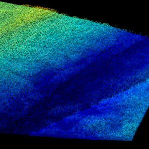
Laser scanning data refers to three-dimensional point-like data depicting the ground and objects on the ground. Each point is provided with x, y and z coordinate information. Laser scanning data 0.5 p has been spaced out from Laser scanning data 5 p's density of 5 p/m² to a density of 0.5 p/m². Laser scanning data 0.5 p is open data, and from 2020 onwards, it will be collected according to the national laser scanning programme (in Finnish): https://www.maanmittauslaitos.fi/laserkeilaus-ja-ilmakuvaus. For the time being, it is available only from certain parts of Finland. The product belongs to the open data of the National Land Survey of Finland. More information (in Finnish): https://www.maanmittauslaitos.fi/laserkeilausaineistot.
-

Division into administrative areas (raster) is a dataset depicting the municipal Division of Finland. The dataset Municipal Division is produced in scales 1:10,000, 1:100,000, 1:250,000, 1:1,000,000 and 1:4,500,000. The data included in the dataset in scale 1:10,000 are taken from the Cadastre. Regarding other scales, municipal boundaries have been generalised to suit the scale in question. Division into administrative areas products in raster format include municipal boundaries only. The product is a part of the open data of the National Land Survey.
-
Paikkatiedon tiedostopalvelu (OGC API Processes) tarjoaa kyselyrajapinnan, jonka kautta voi hakea Maanmittauslaitoksen avoimia paikkatietoaineistoja tiedostopaketteina. Aineistot ovat samat, joita voi hakea käyttöliittymän kautta Karttapaikka-palvelun Lataa paikkatietoaineistoja -osiosta. Aineistojen tarkemmat tiedot ovat luettavissa tuotekuvauksista https://www.maanmittauslaitos.fi/kartat-ja-paikkatieto/aineistot-ja-rajapinnat/tuotekuvaukset Palvelu sopii esimerkiksi käyttöön, jossa on tarvetta hakea paikkatietoaineistoja koordinaateilla eli suorakaiteella (Bounding Box) tai polygonirajauksella. Karttapaikan Lataa paikkatietoaineistoja-osiossa nämä valinnat piirretään kartalla, mutta OGC API Processes -palvelussa koordinaatit voi syöttää kyselyparametreina. Hakuparametrit vaihtelevat aineistosta riippuen. Osaa aineistoista voi hakea myös karttalehden, kunnan tai teeman perusteella, tai koko Suomen alueelta. Palvelusta saatavat aineistot ovat Maanmittauslaitoksen avoimen tietoaineiston Nimeä CC 4.0 -lisenssin alaisia. Palvelu tarjotaan avoimena rajapintana, jonka käyttö on maksutonta. Käyttäjä tunnistetaan API-avaimella. https://www.maanmittauslaitos.fi/rajapinnat/api-avaimen-ohje https://www.maanmittauslaitos.fi/paikkatiedon-tiedostopalvelu
-
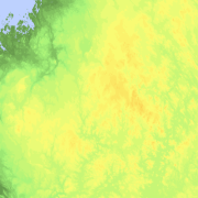
Elevation zones is a raster dataset that visualises elevation of the terrain. The product covers the whole of Finland. There are four product versions available in which the pixel sizes are 32, 64, 128 and 512 metres. The dataset does not contain elevation values; it is a colour image that visualises the height of the terrain above sea level as zones. The sea is shown in light blue in the elevation zone. The product Elevation zones is available as a version that covers the whole country and as versions that cover a certain area. The product belongs to the open data of the National Land Survey of Finland.
-
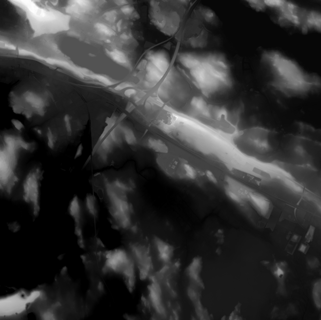
Elevation model 2 m is a model depicting the elevation of the ground surface in relation to sea level. Its grid size is 2 m x 2 m. The dataset is based on laser scanning data, the point density of which is at least 0.5 points per square metre. The product's coverage is based on nationwide laser scanning. In some parts of the outer archipelago or the eastern border, the elevation model is not available. Elevation model 2 m is produced in two quality classes: the elevation accuracy in class I is on average 0.3 metres and the elevation accuracy in class II varies between 0.3 metres and one metre. The product belongs to the open data of the National Land Survey of Finland.
-
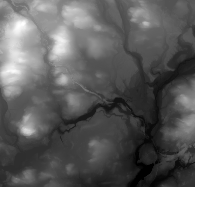
Elevation model 10 m depicts the elevation of the ground surface of the whole of Finland in relation to sea level. Its grid size is 10 m x 10 m and the accuracy of elevation data 1.4 metres. The product belongs to the open data of the National Land Survey of Finland.
-

The Topographic database is a dataset depicting the terrain of all of Finland. The key objects in the Topographic database are the road network, buildings and constructions, administrative borders, geographic names, land use, waterways and elevation. Aerial photographs, scanning data and data provided by other data providers are utilised in updating the Topographic database. The updating is done in close cooperation with the municipalities. Field checks in the terrain are also needed to some extent, mostly as regards the classification of features. The topographic database is used in the production of other map products and in various optimisation tasks. The product belongs to the open data of the National Land Survey of Finland.
-

The Background map is a dataset product series in raster format that depicts the whole of Finland and that is meant for web use as a background material for thematic data. Its key objects are road names, roads and railways, buildings and constructions, administrative borders, geographical names, waterways, land use and addresses of buildings (from Ryhti/Finnish Environment Institute). The product belongs to the open data of the National Land Survey of Finland.
-
The themes of the Topographic database and Topographic map raster series (scale 1:10,000) have been compiled into seven theme entities, theme rasters, required by the Inspire directive: hydrography, elevation, traffic network, land use, land cover, place names and buildings. In addition to the above, the theme rasters also include the municipal division, road names and map sheet division as separate themes. The theme rasters have not been implemented according to the imaging technology defined in the Inspire directive. They will be produced later. The product belongs to the open data of the National Land Survey of Finland.
-
Laser scanning data refers to three-dimensional point-like data depicting the ground and objects on the ground. Each point is provided with x, y and z coordinate information. Laser scanning data is available from all of Finland. The product belongs to the open data of the National Land Survey of Finland. From 2020 onwards, laser scanning data according to the laser scanning programme will be produced. The product description of the 'Laser scanning data 5 p' according to the scanning programme is available: https://www.maanmittauslaitos.fi/en/maps-and-spatial-data/expert-users/product-descriptions/laser-scanning-data-5-p. A spaced-out open dataset will be created from the new Laser scanning data 5 p: https://www.maanmittauslaitos.fi/en/maps-and-spatial-data/expert-users/product-descriptions/laser-scanning-data-05-p. The characteristics of this dataset correspond to the Laser scanning data 2008–2019 dataset.